Natural Sciences
The Man and the Biosphere (MAB) Programme of UNESCO emphasizes the delicate balance between development and conservation by encouraging research and technical training. It targets the ecological, social and economic dimensions of biodiversity.
The programme is implemented on the ground by establishing Biosphere Reserves — areas of terrestrial and coastal ecosystems that conserve and sustain the environment. These reserves act, in some ways, as ‘living laboratories,’ testing and demonstrating the integrated management of land, water and biodiversity.
To date, the World Network of Biosphere Reserves (WNBR) includes 669 sites in 120 countries, with three from the Philippines: Puerto Galera (designated in 1977), Palawan (designated in 1990) and Albay (designated in 2016).
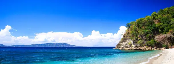
Puerto Galera Biosphere Reserve is situated on Mindoro Island, about 120 kilometers south of Manila. Its 23,200 hectares make up the northern tip of Mindoro Island and are bounded to the north by the Verde Island Passage, to the west by the Camarong River and to the east by the municipality of San Teodoro. Ecosystems represented here are savannas and grasslands, dipterocarp forests, mossy forests, mangrove, coral reefs and coastal ecosystems as well as agroforestry systems. A wide variety of endemic species are present, including tamaraw (Bubalus mindorensis). Their traditional source of income used to be fishing and subsistence agriculture. However, after the boom of tourism at the end of the 1970s, the service sector became more and more important. The conservation of coral reefs has been recognized as one of the main tasks of the biosphere reserve since healthy coral reefs are important for the conservation of biodiversity, the maintenance of the traditional lifestyle and culture, tourism revenues, education and research.
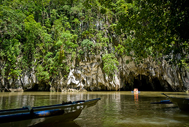
The province of Palawan is known as the Philippine’s “last ecological frontier.” The Palawan BR is an archipelago composed of a main island and more than 1,700 islands, located at the western part of the Philippines. It is endowed with rich natural resources and highly diverse flora and fauna found in both land and sea. According to the International Union for Conservation of Nature (IUCN) classification, it has 105 out of the 475 threatened species in the Philippines. Of the 105 threatened species, 67 are endemic to the Philippines, while 42 of the 67 are Palawan endemics. Its coastal and marine ecosystems include coral reefs (379 species of corals), seagrass meadow (13 species), and mangroves (31 species, distributed in 44,500 hectares of mangrove forests, the highest remaining mangrove cover in the Philippines). It also harbors several marine mammals such as marine turtles, dugong, and whale shark. The characteristics of terrestrial and freshwater ecosystems are also diverse. It is composed of old growth and second growth tropical rainforest, karstic limestone, forest over ultramafic rocks, casuarinas and beach forest. They serve as habitats to freshwater fish (total of 18 Philippines endemics), amphibians (26 Philippines endemics), reptiles (69 species), birds (279 species), migratory birds, terrestrial mammals (58 species, of which 16 are Palawan endemics). The Palawan BR is also home to approximately 57 ethnolinguistic groups with 3 indigenous peoples: the Tagbanua, Palaw’an, and the Bataks. The major economic activities are agriculture and fisheries. Other important industries are tourism, on-shore and off-shore mining, gathering of minor forest products, and pearl farming.
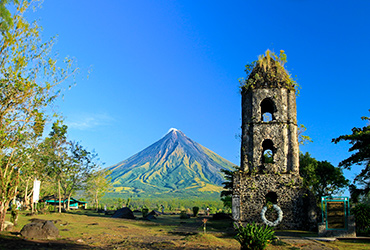
Located at the southern end of the Luzon Island, the biosphere covers some 250,000 hectares. The terrestrial elevation of the site culminates at 2,462 meters and its marine part reaches a depth of 223 below sea level. The site’s high conservation value is constituted, notably, by its 182 terrestrial plant species, 46 of which are endemic. Its marine and coastal ecosystems number 12 species of mangrove, 40 species of seaweed or macro-algae, and 10 species of sea grass. Five of the world’s seven species of marine turtles are to be found in Albay.
The proposed Camarines Sur Biosphere Reserve is located in the Bicol Region in Luzon of the Philippines. The province borders Camarines Norte and Quezon to the northwest, and Albay to the south. To the east lies the island province of Catanduanes across the Maqueda Channel. Camarines Sur is the largest among the six provinces in the Bicol Region both by population and land area. An assessment of the proposed biosphere reserve reveals an endless list of species endemic and unique in the region. Notable are endemic mammals (horshoe bats, fruit bats, and insectivorous bats) species of plants (Rafflesia baletii, Stronglydon botrys) and significant populations of avian fauna (blue breastesd nuthatch, Isarog flycatcher, Philippine hornbills) to name a few that are distinct of the region. Within the province lies Lake Buhi, where the smallest commercially harvested fish, the Sinarapan (Mistichthys luzonensis), can be found.
The proposed Mt. Malindang Range Natural Park (MMRNP) Biosphere Reserve lies within the Province of Misamis Occidental, Mindanao, Philippines. Its impact areas also extend to the two provinces of Zamboanga del Norte and Zamboanga del Sur. MMRNP rises from 600 meters above sea level to 2,404 meters above the mean sea level. It constitutes seven major peaks, with the highest peak being Mt. Malindang at 2,402 meters above sea level. The mountain range was believed to have been formed through series of volcanic activities. Several indicators of such activities are found in the park that include an 8-hectare crater lake locally known as Lake Duminagat and two big sunken areas (more than 20 hectares each) surrounded by high rock walls, cinder cones, dome volcanic plugs, amphitheater structures, extensive distribution of volcanic rocks, carbonized wood found in pyroclastic deposits and three sulfuric hot springs (Sebucal, Tuminawan and Liboron). The entire mountain range is dissected by several canyons, gores and ravines making its terrain very rugged and the forest scenery beautiful. The park landscape emanates from 17 major watersheds draining to the three provinces, its unique and numerous waterfalls, crater lake and dense virgin forests, which host diverse and rare species of flora and fauna. The mystical Lake Duminagat is considered to be a sacred place of the Subanen, named after the crater lake and its crystal clear waters.
PH NatCom, through UNESCO’s Global Geoparks Programme, highlights the need to protect our geological heritage by engaging with local communities.
UNESCO Global Geoparks, within UNESCO’s International Geoscience and Geoparks Programme (IGGP), are single, unified geographical areas where sites and landscapes of international geological significance are managed with a holistic concept of protection, education and sustainable development. Specifically, the Geoparks Programme engages in awareness-raising and develops strategies to mitigate geohazards, such as volcanic eruptions, earthquakes and tsunamis. It also addresses the problems of climate change and the need to sustain our natural resources. By raising awareness of the importance of the area’s geological heritage in history and society, UNESCO Global Geoparks gives local people a sense of pride in their region. The creation of innovative local enterprises, new jobs and high quality training courses is stimulated as new sources of revenue are generated through geotourism, while the geological resources of the area remain protected. To date, there are 119 UNESCO Global Geoparks in 33 countries.
As the country has yet to become part of the UNESCO Global Geoparks Network, PH NatCom encourages specific sites in the Philppines to become UNESCO Global Geoparks. At present, PH NatCom is coordinating with its partners to further the nominations of two sites that have expressed an interest in becoming UNESCO Global Geoparks. These are: 1) Bohol (as initiated by the UP School of Urban and Rural Planning and 2) Mt. Masungi Karst Conservation Area in Tanay, Rizal (initiated by the provincial government of Rizal).
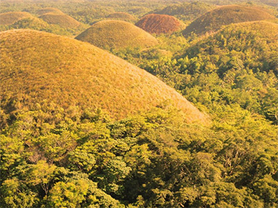
Bohol has a land area of nearly 5,000 square kilometers covered by 25% forestland and 45% farmland. The population lives in 28 coastal villages and 28 inland towns. The most important economic activity is in the agricultural sector with the services and tourism sectors slowly catching up. The island of Bohol is a popular international and local tourist destination because of its white beaches, unique landscapes and cultural treasures. One of the most popular attractions within the province is the Chocolate Hills located in the central portion of the island. It is a unique karst landscape with more than 1,500 individual cone-shaped (haycock) limestone hills (cone karst) with an average elevation ranging from 10 to 80 meters. The brown or chocolate color of the conical hills is named after the color of the vegetation during summer season. Aside from the unique cone-karst terrain, Bohol is also known for its numerous cave formations. In general, Bohol is considered a cave country because of its extensive cave systems. One of its caves is the Hinagdanan Cave located in Panglao Island, 12 kilometers south of the capital Tagbilaran City. Fourteen potential geological sites have been identified in Bohol that could form part of the Bohol UNESCO Global Geopark.
The Masungi Karst Conservation Area, also known as the Masungi Georeserve is a conservation area in the southern Sierra Madre range in Rizal, Philippines, 45 kilometers (28 miles) east of Manila. It centers on the geological formations of Mount Masungi (Masungi Rock), situated 640 meters (2,100 feet) above sea level in the municipality of Tanay. The park is characterized by rugged limestone karst peaks, steep slopes, and surrounding lush mountain rainforests. It also contains several caves, including the Yungib ni Ruben (Ruben’s Cave), which features stalactite and stalagmite formations, as well as a man-made fountain. Another popular attraction in the park is the Sapot (“Cobweb”), a metallic platform with wooden steps that allow visitors to walk on suspended netting above the karst and get a 360-degree view of the Sierra Madre and the Laguna de Bay. The park’s tallest peak, Tatay, also has a viewing deck in its summit. The limestone formations are connected by hanging bridges, rope courses and eco-trails developed by the Masungi Georeserve Foundation and Blue Star Development. On one of the hanging bridges, a wooden cable car-like shelter called Patak (“Water droplet”) can be found, which serves as a rest stop for visitors. The Duyan, a giant rope hammock spanning a few hundred feet, is one of Masungi’s most photographed rope courses. The park was formerly a component of the Mariquina Watershed Reservation. It is home to a variety of fauna, including different kinds of birds, insects, cloud rats, monitor lizards, snakes, monkeys and civets.
The ocean is key to sustaining life on the planet. About 70% of the earth is ocean, which happens to be 97% of the world’s water. The ocean provides about half of the oxygen we breathe. It directly supports the livelihoods of about 500 million people, especially in the poorest nations living in low-lying coastal regions. For many of these nations, ocean-related economic activities, such as tourism and artisanal fisheries support up to 30% of national economies.
In 1960, the Intergovernmental Oceanographic Commission (IOC) of UNESCO was established to promote global cooperation and generate knowledge about the nature and resources of the ocean. This knowledge allows 148 United Nations (UN) member states to more effectively manage the ocean, use its resources in a sustainable way, and protect the marine environment. In developing and disseminating scientific knowledge, IOC educates the general public on how to respond effectively to the unprecedented environmental changes now impacting the world’s ocean. These include the cumulative threats posed by warming sea temperatures, ocean acidification, pollution and a rapidly expanding human population.
The IOC plays a significant role in ensuring that its member states, particularly developing countries, have the capacity needed to achieve the UN SDG No. 14 (conserve and sustainably use the ocean and marine resources).
In support of the IOC at the national level, PH Natcom, through its National Committee on Marine Sciences used to conduct an annual marine outreach programme to various coastal areas in the country, covering the far distant places strategically located at the northernmost part of Luzon (Basco, Batanes) down to the southern and western parts of Mindanao (Zamboanga City, Zamboanga del Sur). The programme served as a venue where knowledge and expertise were shared with local stakeholders to address pressing issues and problems of their respective coastal areas. Responsible stakeholders and agencies were identified, gaps discussed, and possible solutions enumerated.
PH NatCom has yet to establish a new group of experts who will oversee IOC concerns in the country and ensure its active participation in the programme. At present, PH NatCom disseminates information, announcements of trainings, workshops, grants, scholarships to interested individuals and concerned agencies. The country also actively participates in the sessions of the IOC Executive Council where the Philippines is a member until 2017.